“Unlocking the Sky: Discover the Top Applications of Drones”
Bevezetés
Drones, also known as unmanned aerial vehicles (UAVs), have rapidly evolved from niche gadgets to indispensable tools across various industries. Their ability to access hard-to-reach areas, capture high-resolution imagery, and perform tasks autonomously has opened up a myriad of applications. In agriculture, drones are revolutionizing crop monitoring and precision farming. In the construction industry, they provide aerial surveys and progress tracking. Drones are also enhancing public safety through search and rescue missions, disaster response, and traffic management. Additionally, they are being utilized in environmental conservation for wildlife monitoring and anti-poaching efforts. The entertainment industry leverages drones for dynamic filming and photography, while logistics companies explore drone delivery systems to expedite shipping. These diverse applications underscore the transformative impact of drone technology in modern society.
Aerial Photography And Videography
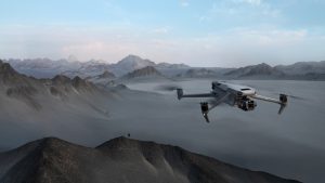
Drones have revolutionized various industries, and one of the most significant areas where they have made a substantial impact is aerial photography and videography. The ability to capture stunning, high-resolution images and videos from unique perspectives has opened up new possibilities for professionals and hobbyists alike. As technology continues to advance, the applications of drones in this field are expanding, offering innovative solutions and enhancing the quality of visual content.
Initially, drones were primarily used for military purposes, but their potential for civilian applications quickly became apparent. In the realm of aerial photography and videography, drones provide an unparalleled vantage point, allowing photographers and videographers to capture breathtaking landscapes, cityscapes, and events from angles that were previously impossible or extremely difficult to achieve. This capability has transformed the way visual stories are told, providing a fresh and dynamic perspective that captivates audiences.
One of the most prominent applications of drones in aerial photography and videography is in the film and entertainment industry. Filmmakers can now create dramatic, sweeping shots that add a cinematic quality to their productions. Drones equipped with high-definition cameras can smoothly navigate through tight spaces, follow moving subjects, and capture complex scenes with ease. This has not only enhanced the visual appeal of films and television shows but has also reduced production costs and time, as drones can often replace more expensive and cumbersome equipment like cranes and helicopters.
In addition to the entertainment industry, drones have found a significant role in real estate marketing. Real estate agents and property developers use drones to create compelling visual content that showcases properties from a bird’s-eye view. Aerial footage can highlight the layout of a property, its surroundings, and key features such as gardens, pools, and nearby amenities. This immersive experience helps potential buyers get a better sense of the property, often leading to quicker sales and higher engagement rates.
Moreover, drones are increasingly being used in the tourism and travel industry. Travel agencies, resorts, and tourism boards leverage aerial photography and videography to promote destinations and attract visitors. Stunning aerial shots of beaches, mountains, and cultural landmarks can evoke a sense of wanderlust and inspire people to explore new places. This visual storytelling is a powerful marketing tool that can significantly boost tourism and local economies.
Another noteworthy application is in the field of journalism and news reporting. Drones enable journalists to cover events from a unique perspective, providing comprehensive coverage of natural disasters, protests, and other significant occurrences. Aerial footage can offer a broader context and a clearer understanding of the scale and impact of events, enhancing the quality of news reporting. This capability is particularly valuable in situations where ground access is limited or dangerous.
Furthermore, drones are being utilized in environmental monitoring and conservation efforts. Researchers and conservationists use drones to capture aerial images and videos of wildlife habitats, forests, and other natural areas. This data is crucial for monitoring changes in the environment, tracking animal populations, and assessing the impact of human activities. Aerial photography and videography provide a non-intrusive way to gather information, ensuring minimal disturbance to wildlife and ecosystems.
In conclusion, the applications of drones in aerial photography and videography are vast and varied, offering innovative solutions across multiple industries. From enhancing cinematic experiences and real estate marketing to promoting tourism and supporting environmental conservation, drones have transformed the way visual content is created and consumed. As technology continues to evolve, the potential for drones in this field will only grow, paving the way for even more exciting and impactful applications.

Agriculture And Crop Monitoring
Drones have revolutionized various industries, and agriculture is no exception. The integration of drone technology into farming practices has opened up new avenues for efficiency, precision, and sustainability. One of the most significant applications of drones in agriculture is crop monitoring. This advanced method of surveillance and data collection has transformed traditional farming, offering numerous benefits that were previously unattainable.
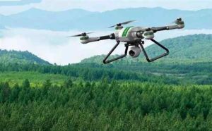
To begin with, drones equipped with high-resolution cameras and multispectral sensors provide farmers with detailed aerial imagery of their fields. This bird’s-eye view allows for the early detection of issues such as pest infestations, diseases, and nutrient deficiencies. By identifying these problems at an early stage, farmers can take prompt corrective actions, thereby minimizing crop damage and loss. Consequently, this leads to higher yields and better-quality produce.
Moreover, drones facilitate precision agriculture by enabling site-specific crop management. Through the use of GPS technology and sophisticated software, drones can create precise maps of fields, highlighting areas that require attention. For instance, they can identify zones with varying levels of soil moisture, allowing farmers to implement targeted irrigation strategies. This not only conserves water but also ensures that crops receive the optimal amount of hydration, promoting healthier growth.
In addition to irrigation management, drones play a crucial role in the application of fertilizers and pesticides. Traditional methods often result in the overuse or underuse of these chemicals, leading to environmental harm and increased costs. Drones, on the other hand, can apply fertilizers and pesticides with pinpoint accuracy, reducing waste and minimizing the impact on surrounding ecosystems. This precision application also helps in maintaining the balance of beneficial insects and microorganisms in the soil, which are essential for sustainable farming.
Furthermore, drones are instrumental in crop health assessment through the use of multispectral and thermal imaging. These technologies can detect variations in plant health that are invisible to the naked eye. For example, thermal imaging can identify areas of a field that are experiencing heat stress, while multispectral imaging can reveal chlorophyll levels, indicating the overall health and vigor of the crops. By analyzing this data, farmers can make informed decisions about crop management practices, such as adjusting planting densities or altering fertilization schedules.
Another significant advantage of drone technology in agriculture is its ability to monitor large areas quickly and efficiently. Traditional methods of crop monitoring, such as manual inspections or satellite imagery, can be time-consuming and less accurate. Drones, however, can cover vast expanses of farmland in a fraction of the time, providing real-time data that is both accurate and actionable. This rapid assessment capability is particularly beneficial during critical periods of the growing season, such as planting and harvest times, when timely information is crucial for decision-making.
In conclusion, the application of drones in agriculture and crop monitoring has brought about a paradigm shift in farming practices. By offering precise, real-time data and enabling targeted interventions, drones have enhanced the efficiency, productivity, and sustainability of modern agriculture. As technology continues to advance, it is likely that the role of drones in farming will expand even further, paving the way for a more innovative and resilient agricultural sector.
Search And Rescue Operations
Drones have revolutionized various industries with their advanced capabilities, and one of the most impactful applications is in search and rescue operations. These unmanned aerial vehicles (UAVs) have become indispensable tools for emergency responders, offering a range of benefits that significantly enhance the efficiency and effectiveness of rescue missions. As technology continues to advance, the role of drones in search and rescue operations is expected to expand even further.
One of the primary advantages of using drones in search and rescue operations is their ability to quickly cover large areas. Traditional search methods, such as ground patrols and manned helicopters, can be time-consuming and resource-intensive. In contrast, drones can be deployed rapidly and can scan vast regions in a fraction of the time. This speed is crucial in emergency situations where every second counts, such as locating missing persons in remote or hazardous environments.
Moreover, drones are equipped with high-resolution cameras and thermal imaging technology, which significantly enhance their search capabilities. Thermal cameras can detect heat signatures, making it possible to locate individuals even in low-visibility conditions such as dense forests, fog, or nighttime. This technology is particularly useful in scenarios where traditional search methods might fail, providing rescuers with critical information that can lead to successful outcomes.
In addition to their speed and advanced imaging capabilities, drones offer a level of safety that is unmatched by other search methods. Rescuers often face dangerous conditions, such as natural disasters, rough terrains, or unstable structures. By using drones, emergency teams can assess the situation from a safe distance, reducing the risk to human life. This remote assessment allows for better planning and coordination, ensuring that rescue efforts are both effective and safe.
Furthermore, drones can be equipped with various sensors and communication devices that enhance their functionality in search and rescue missions. For instance, some drones are fitted with loudspeakers and two-way communication systems, enabling rescuers to communicate with stranded individuals. This capability is invaluable in providing reassurance and instructions to those in distress, potentially saving lives.
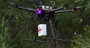
Another significant benefit of drones in search and rescue operations is their ability to deliver essential supplies to inaccessible areas. In situations where ground access is impossible or too dangerous, drones can transport medical supplies, food, water, and other necessities to those in need. This capability not only provides immediate relief but also buys time for rescuers to reach the affected individuals.
The integration of artificial intelligence (AI) and machine learning into drone technology is further enhancing their effectiveness in search and rescue operations. AI-powered drones can analyze vast amounts of data in real-time, identifying patterns and anomalies that might indicate the presence of a missing person. This advanced analysis can significantly reduce the time required to locate individuals, increasing the chances of a successful rescue.
As the technology continues to evolve, the potential applications of drones in search and rescue operations are expanding. Innovations such as swarm technology, where multiple drones work together in a coordinated manner, are being explored to further enhance search efficiency. Additionally, advancements in battery life and autonomous navigation are expected to extend the operational range and duration of drones, making them even more valuable in emergency situations.
In conclusion, drones have become a vital asset in search and rescue operations, offering unparalleled speed, safety, and advanced capabilities. Their ability to quickly cover large areas, utilize thermal imaging, and deliver essential supplies has transformed the way emergency responders conduct rescue missions. As technology continues to advance, the role of drones in search and rescue operations is set to become even more significant, ultimately saving more lives and improving the efficiency of emergency response efforts.

Infrastructure Inspection And Maintenance
Drones, also known as unmanned aerial vehicles (UAVs), have revolutionized various industries with their versatility and efficiency. One of the most significant applications of drones is in the field of infrastructure inspection and maintenance. This sector has traditionally relied on manual inspections, which are often time-consuming, costly, and sometimes hazardous. However, the advent of drone technology has introduced a paradigm shift, offering a safer, faster, and more cost-effective alternative.
To begin with, drones are increasingly being used for the inspection of bridges. Bridges are critical components of transportation networks, and their structural integrity is paramount. Traditional inspection methods often require lane closures, scaffolding, and even divers for underwater inspections. Drones, equipped with high-resolution cameras and sensors, can easily access hard-to-reach areas, capturing detailed images and data without disrupting traffic. This not only enhances safety for inspectors but also minimizes inconvenience for the public.
Similarly, drones have proven invaluable in the inspection of power lines and electrical grids. Power companies face the daunting task of maintaining extensive networks of transmission lines, often located in remote or difficult-to-access areas. Drones can quickly survey these lines, identifying issues such as corrosion, vegetation encroachment, or damaged components. By providing real-time data, drones enable utility companies to address problems before they escalate, thereby reducing the risk of power outages and enhancing the reliability of the electrical grid.
In addition to bridges and power lines, drones are also being utilized for the inspection of pipelines. Pipelines, whether for oil, gas, or water, are critical infrastructure assets that require regular monitoring to prevent leaks and ensure operational efficiency. Traditional inspection methods, such as ground patrols or manned aircraft, can be labor-intensive and expensive. Drones offer a more efficient solution, capable of covering vast distances quickly and capturing high-resolution imagery that can be analyzed for signs of wear, corrosion, or other potential issues. This proactive approach to maintenance helps in mitigating environmental risks and ensuring the safe transport of essential resources.
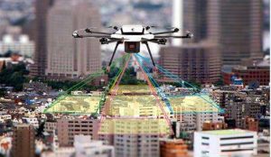
Moreover, drones are making significant strides in the inspection of buildings and construction sites. Construction companies are leveraging drone technology to monitor progress, inspect structural elements, and ensure compliance with safety standards. Drones can provide a bird’s-eye view of a construction site, offering insights that are difficult to obtain from the ground. This capability is particularly useful for large-scale projects, where traditional inspection methods may be impractical. By facilitating more frequent and thorough inspections, drones help in identifying potential issues early, thereby reducing the likelihood of costly delays or rework.
Furthermore, drones are being employed in the maintenance of renewable energy infrastructure, such as wind turbines and solar panels. Wind turbines, often located in offshore or remote areas, pose significant challenges for manual inspections. Drones can easily navigate these environments, capturing detailed images of turbine blades and other components. Similarly, drones can survey large solar farms, identifying damaged or malfunctioning panels with precision. This targeted approach to maintenance ensures that renewable energy systems operate at peak efficiency, contributing to the overall sustainability of energy production.
In conclusion, the application of drones in infrastructure inspection and maintenance is transforming the way industries approach these critical tasks. By offering a safer, faster, and more cost-effective solution, drones are enhancing the efficiency and reliability of infrastructure systems. As drone technology continues to advance, its role in infrastructure inspection and maintenance is likely to expand, further solidifying its position as an indispensable tool in the modern industrial landscape.

Environmental Monitoring And Conservation
Drones, also known as unmanned aerial vehicles (UAVs), have revolutionized various sectors, and their application in environmental monitoring and conservation is particularly noteworthy. These advanced technologies offer unprecedented capabilities for observing, analyzing, and protecting our natural world. As we delve into the top applications of drones in this field, it becomes evident that their impact is both profound and multifaceted.
To begin with, drones have significantly enhanced the efficiency and accuracy of wildlife monitoring. Traditional methods of tracking animal populations often involve labor-intensive and invasive techniques, which can be stressful for the animals and hazardous for researchers. In contrast, drones equipped with high-resolution cameras and thermal imaging sensors can capture detailed images and videos from a safe distance. This allows scientists to monitor species in their natural habitats without disturbing them, providing invaluable data on behavior, population dynamics, and migration patterns. Consequently, this information can inform conservation strategies and help protect endangered species.
Moreover, drones play a crucial role in habitat mapping and vegetation analysis. By utilizing advanced imaging technologies such as LiDAR (Light Detection and Ranging) and multispectral cameras, drones can create detailed, three-dimensional maps of various ecosystems. These maps are essential for understanding the structure and health of habitats, identifying areas of deforestation, and assessing the impact of human activities on the environment. For instance, in forested regions, drones can detect illegal logging activities and monitor reforestation efforts, ensuring that conservation initiatives are effectively implemented.
In addition to habitat mapping, drones are instrumental in monitoring environmental changes and natural disasters. Climate change has led to an increase in the frequency and intensity of events such as wildfires, floods, and hurricanes. Drones can be rapidly deployed to assess the extent of damage, track the progression of these events, and provide real-time data to emergency response teams. This capability not only aids in disaster management but also contributes to long-term environmental monitoring by documenting changes in landscapes and ecosystems over time.
Furthermore, drones are invaluable in the fight against poaching and illegal wildlife trade. Poaching remains a significant threat to many endangered species, and traditional anti-poaching efforts often fall short due to the vast and remote areas that need to be patrolled. Drones equipped with night vision and thermal cameras can cover large areas quickly and efficiently, detecting poachers and alerting authorities in real-time. This proactive approach has proven to be a game-changer in protecting vulnerable wildlife populations.
Another noteworthy application of drones in environmental conservation is their use in marine and coastal monitoring. Oceans and coastal areas are critical to global biodiversity, yet they face numerous threats, including pollution, overfishing, and habitat destruction. Drones can survey large expanses of water, monitor coral reefs, track marine species, and even collect water samples for analysis. This data is crucial for understanding the health of marine ecosystems and implementing measures to mitigate human impact.
In conclusion, the integration of drones into environmental monitoring and conservation efforts has opened up new possibilities for protecting our planet. Their ability to provide detailed, real-time data from hard-to-reach areas makes them an indispensable tool for researchers and conservationists. As drone technology continues to advance, it is likely that their applications in this field will expand even further, offering new solutions to some of the most pressing environmental challenges of our time.

Következtetés
Drones have revolutionized various industries with their versatile applications. In agriculture, they enable precision farming through crop monitoring and spraying. In the construction sector, drones facilitate site surveys and progress tracking. They are crucial in disaster management for search and rescue operations and damage assessment. Drones enhance security and surveillance, providing real-time monitoring in both public and private sectors. In media and entertainment, they offer unique aerial photography and videography perspectives. Additionally, drones are pivotal in logistics, enabling efficient delivery services. Overall, drones significantly improve efficiency, safety, and data collection across multiple fields.
